
See what gateway to the
monongahela national forest
has to offer

during the winter season, please click the link below to be aware of road and facility closings within the national forest.
Monongahela Forest winter access closing information link
THESE ACTIVITIES HAVE THEIR OWN TABs

mountain biking
There are numerous trails for all skill levels of mountain biking throughout the Monongahela National Forest.
See the link within this site MOUNTAIN BIKING for more detailed information.

hiking / backpacking
Cranberry Wilderness (47,815 acres) and Cranberry Backcountry (14,000 acres) make up one of the largest backpacking areas east of the Mississippi River.
See the link within this site HIKING/BACKPACKING for more detailed information.


Cranberry glades
Near the southern end of the Monongahela National Forest lies Cranberry Glades Botanical Area, a high-altitude cluster of boreal-type bogs that are typically found in Canada and higher elevations that form along the headwaters of the Cranberry River.
A boardwalk loop (roughly 1/2 mile) has been built to protect the fragile bogs and winds through the area where you can view a variety of unique plants including cranberries, sphagnum moss, skunk cabbage and even two carnivorous plants—purple pitcher and sundew.
The glades serve as breeding ground for a variety of birds including thrushes, warblers and finches. In the evening you might even catch a glimpse of a black bear snacking on some skunk cabbage.
Learn more about the unique features of this natural landmark by guided tours arranged by the Cranberry Mountain Nature Center (open mid-April through mid-October).
Accessibility:
The boardwalk and restrooms are wheelchair accessible.
Link for address: Cranberry Glades

the falls of hills creek
A series of three falls that cascade 20 feet, 45 feet, and 65 feet. The walkway to the first fall is paved and handicapped accessible.
The journey afterward becomes more strenuous as a series of stairs, boardwalks, and pathways guide visitors to the two remaining lower falls. The viewing platform for the third and largest of the falls (the second highest falls in West Virginia) is reached by an elaborate metal stairway of 382 steps.
For wildflower enthusiasts, in the spring and early summer, the forest carpet is alive with over 40 species of blooms.
The Falls of Hills Creek are also awe inspiring in the winter with the spectacle of frozen falls.
Visitors should allow an hour, or more, to traverse the three-quarter-mile route to the lowest falls from the parking area during the warmer months, far longer during the challenging winter.
Accessibility:
The first waterfall is wheelchair accessible.
Link for address: Falls of Hills Creek

highland scenic highway
The Highland Scenic Highway is a beautiful corridor through the Monongahela National Forest. It extends 43 Miles from Richwood to U.S. Route 219, seven miles north of Marlinton. The Highway follows State Route 39/55 for 21 miles from Richwood to the Cranberry Mountain Nature Center, it then turns into State Route 150 for a 22 mile parkway section. Route 150 was built between 1965-1981 entirely for the purpose of offering major access to the unspoiled forests and high peaks at the headwaters of the Williams and Cranberry Rivers. Elevation rises from 2,325 feet in Richwood to over 4,500 feet along the parkway. Fall foliage is spectacular along the parkway and draws countless tourists during the autumn season. There are 4 scenic overlooks that provide incredible views of the Allegheny Highlands. Barrier-free picnic shelters and restrooms are located at each overlook.
The highway is a two-lane paved road. The parkway is not maintained during the winter months, which generally range from early December to March.
Commercial traffic is prohibited.
Accessibility:
The shelters and restrooms are wheelchair accessible.

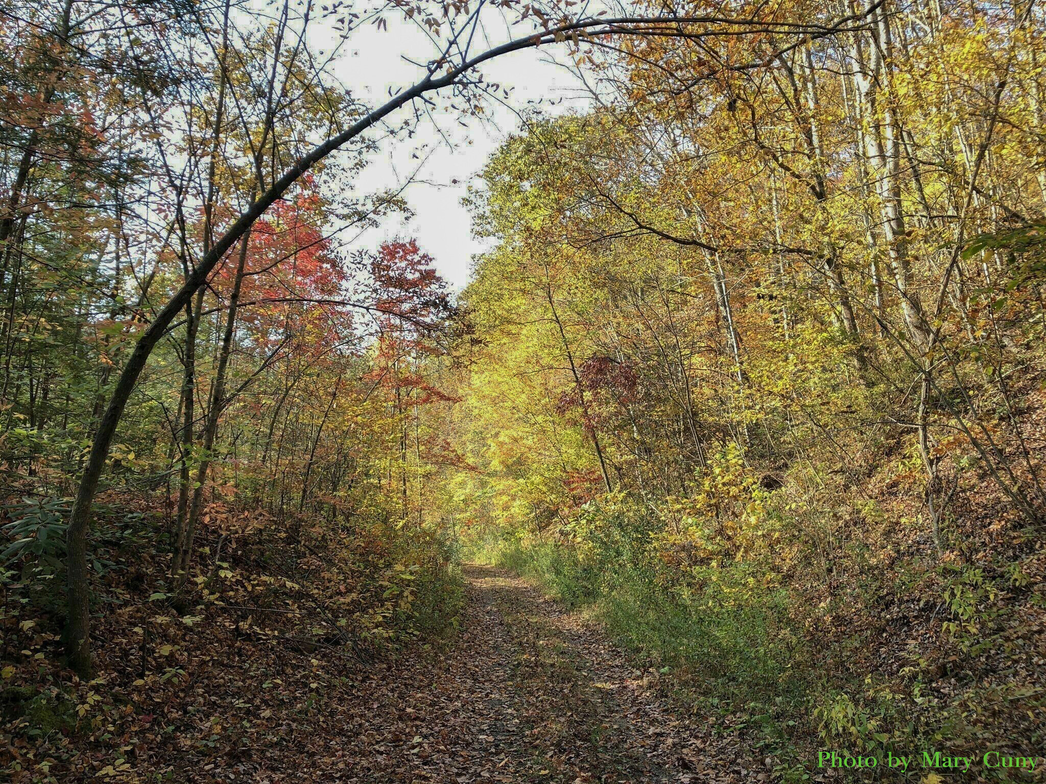
LEAF PEEPING
One of the most spectacular areas in the state to be wowed by the colorful array of fall foliage is in the surrounding Monongahela National Forest. Accessible by way of Route 39 which runs through downtown Main Street in Richwood, the "Gateway to the Mon" never disappoints. As soon as you arrive in Richwood city limits, you're surrounded by mountains popping with color. After stopping to experience art, award winning food, fresh roasted coffee, gifts and a history lesson, or two, continue one mile on Route 39 into the National Forest. Traveling the designated byway, Routes 39 & 150, you'll experience the forest ablaze with a spectacle of colors. From Richwood's elevation of 2,200 feet climbing to nearly 4,500 feet, the Highland Scenic Parkway has four developed scenic overlooks with handicap accessible restrooms and vast breathtaking views. Leaves in the area peak mid to late October with the higher elevations generally a week ahead of the lower lying areas.
Accessibility:
The shelters and restrooms on the Highland Scenic Highway are wheelchair accessible.

summit lake
Summit Lake is a 43-acre cold water reservoir located in Greenbrier County, 10 miles east of Richwood in the Gauley Ranger District of the Monongahela National Forest. It is a man-made lake built in 1955 with a maximum depth of 20 feet and an average depth of 10 feet. It is a popular destination for anglers, as well as kayakers and paddle boarders seeking calm water and gorgeous views.
Swimming is prohibited.
A graveled boat ramp and two fishing platforms are available at the lake. Only electric trolling motors only are allowed and fishing with live minnows is prohibited.
The lake is a popular year-round fishing destination with an abundant supply of trout, large and smallmouth bass and bluegill. (see the fishing tab on this site for more information) The lake is stocked with trout by the WV DNR several times in the year. A National Forest Stamp is required.
It serves as the starting point for the annual Scenic Mountain Triathlon
Accessibility:
The fishing platforms and restrooms are wheelchair accessible.
Link for address: Summit Lake

Kayaking
The Cherry River provides a good novice to intermediate kayak run that is bordered by roads the entire way. Rapids are generally Class II and Class III intermediate (though this can fluctuate in periods of prolonged rain), making a great run for non-stop action. At an elevation of just more than 2,000 feet, the river has a series of rock formations, eddies, and an occasional hole to navigate through.The land around the river is mostly rural and mountainous, which provides an incredible scenic view the entire way to the more rigorous Gauley River (of which it is a tributary). One of the most popular stretches is the 9 miles from the Comstock Bridge to the mouth of the Gauley.
For a longer run, begin at the North Fork of the Cherry River, which is 13 miles to the mouth of the Gauley and mostly Class III, with a couple of Class IV rapids and dams downstream. A popular shorter run is the South Fork of the Cherry River, which is 6 miles and Class II-III.
Access points are:
Four Seasons Lodge/Rudolph Falls / North Fork of the Cherry River
Cherry River South Side Bridge, just before bridge, look the sign for Fire Department Access
Comstock Bridge, next to the Cherry River Elementary School off of Routes 39/55
Dain Park, across from Go Mart just inside the city limits
Fenwick Post Office
Whitewater resource information link

PADDLE BOARDING
Paddle boarding (and kayaking) is popular on Summit Lake due to the beautiful calm water and lush forest views. Swimming is prohibited on the lake.
Summit Lake is 10 miles east of Richwood within the Monongahela National Forest.
Link for address: Summit Lake

swimming holes
Richwood is known for swimming holes where generations have spent their summers plunging into the cold waters of the local rivers. There are countless locations, most of which are kept under wraps by the locals. If you’re feeling adventuresome, ask a local for one of their secret spots!
Below is a list of a few well known favorites:
Rudolph Falls is located just outside the city limits behind Four Seasons Lodge. This section of the North Fork Cherry River has a large rock for sunbathing and picnics with water falls running along both sides plunging into a nice deep swimming hole. There is a rope swing for those looking for a little adrenaline rush!
Woodbine is located at Woodbine Picnic Area. Hop into the chilly Cranberry River swimming hole with a smooth flat bottom and large rock to jump from for thrill seekers.
Big Rock is located just beyond Woodbine across from the Big Rock campsite. It is a large swimming area on the cool Cranberry River.

richwood city pool
The Richwood City Pool is located at the City Park and is open from early June until late August. Featuring as sloping 3’ to 6’ deep swim area and a low diving board in the adjacent 12’ dive area. Snacks are for sale and many days throughout the summer are business/community sponsored “free swim days”. There are also occasional night swims.
Located at 84 Riverside Drive

stargazing
Due to its proximity to the national forest, one doesn’t have to travel far outside of the city limits to experience a stargazer’s paradise. Some local favorite spots to view from are Summit Lake and the Highland Scenic Highway. On nights when the moon is in its new or crescent phase the sky is littered with stars and the Milky Way can be faintly seen with the naked eye.

disc golf
The disc golf course is located within the Richwood City Park. It is a mostly flat, 9 hole, par 27 course. Perfect for beginners and advanced players looking to try varied shots without much risk of losing discs.
Located at 84 Riverside Drive


richwood parks
Richwood has 3 local parks.
Richwood City Park has a regulation little league baseball field, skate park, disc golf course, basketball court and city pool. They also have a picnic shelter available for picnics and parties. There is a playground for children including swings.
Located at 84 Riverside Drive
Pratt Park has two fields that serve as home fields for Richwood High School’s baseball and softball teams. It also has a walking track with 3 laps equalling a mile. There are also several outdoor fitness machines that use body weight as resistance. There is a shelter than can be used for picnics and parties.
Located at 10 Maust Avenue
Dain Park has an open field that can be used for recreational activities and a large playground for children. There is a shelter that can be used for picnics and parties. It also serves as a “put in” area for kayaking and a large swimming hole.
Located at 88 Green Street
cranberry Tri-Rivers rail trail
The Cranberry Tri-Rivers Rail Trail is one of the longest rail trails in southern West Virginia. It’s a fun adventure along a now-defunct logging rail line that once followed the paths of 3 different rivers: the Cherry, Cranberry, and Gauley rivers. Mountain bikers can ride along this meandering trail for 16.5 miles, through the wilderness of Nicholas County. There are 3 bridges along the trail, and 2 of them are built atop original railroad trestles that span the rivers. Midway, you will come upon the impressive 640-foot, horseshoe-shaped Sarah’s Tunnel. Move through the tunnel quickly—it is completely dark in the center!After the tunnel, there’s roughly another 8 miles along the trail to the turnaround point.
If you decide to do the full trail out and back, it’s 33 miles. But, there is always the option of turning back at any point along the way so you can make your ride as long or short as you want. You can keep a high cadence on this trail, so with a quick snack at the halfway point, an experienced cyclist can make the trip in 4 hours. A beginning or intermediate biker should probably add at least another hour to their trip. Many people choose to leave a car at the end of the 16.5 section instead of making the round trip.
Starting point is at the Richwood Area Chamber of Commerce office at 38 Edgewood Avenue.

helios park
The Helios Park is a community project that had a variety of funders and facilitators, and which ultimately resulted in the creation of a completely unique pocket park space in Richwood. The park hosts solar panels donated by Create West Virginia, the panels are mounted on solar trellis designed by WV architect Thom Worlledge and constructed of white oak donated by local Laurel Creek Hardwoods. The park body was designed by WV landscape architect Todd Schoolcraft and includes pervious concrete walkway (enhances drainage), native vegetation rain garden, and a colorful human sundial which enables visitors to determine the time of day. The solar energy is fed into the grid via a “Net-meter” which provides a positive return to the city electric bill.
Located at the intersection of Oakford and Edgewood Avenues

bird watching
The Monongahela National Forest is over 908,000 acres of diverse habitat used by 230 species of birds. The forest stands of various tree species and age classes, and non-forest areas--such as wetlands, cliffs, grassy meadows, and cascading streams--all provide places for birds to feed, rest, and raise their young.
This diverse landscape provides habitat for 70 species of resident birds, 89 breeding neotropical migrants, and 71 non-breeding migratory bird species. The Forest Service encourages you to try birding on the National Forest. Special efforts are taken to protect and provide the necessary habitats for birds--food-producing trees and shrubs are planted for food and cover; during timber harvest/firewood cutting, many cavity trees and snags are saved for nesting, feeding, and roosting sites. Through birding, you can become familiar with the Forest Service's role in protection and management which includes recreation, timber, wildlife, water, wilderness, and range resources.
It is home to a wide variety of birds including the Red Tailed Hawk, Northern Warblers, Ruffed Grouse, Barn Owl, Barred Owl, Great Horned Owl, Olive-sided Flycatcher, Alder Flycatcher, Blue-headed Vireo, Common Raven, Red-breasted Nuthatch, Brown Creeper, Winter Wren, Veery, Hermit Thrush, Northern Waterthrush, Mourning Warbler, Hooded Warbler, American Redstart, Magnolia Warbler, Blackburnian Warbler, Chestnut-sided Warbler, Black-throated Blue Warbler, Black-throated Green Warbler, Canada Warbler, Dark-eyed Junco, Purple Finch, and Red Crossbill to name a few.
Visit the Cranberry Mountain Nature Center for more information and books pertaining to the local Aves.

hunting
The national forest has a variety of animals including deer, bear and turkey with designated hunting seasons. See the WV DNR site via the links below for all information regarding gun, bow and trapping rules and regulations.
To purchase a license, you can visit a participating retailer or online via this LINK.

atv
Good Evening Ranch Offroad Park is located 22 miles from Richwood in Canvas and offers trails available for all skill levels and difficulties.
Open to full size rigs as well as ATVs and SxS's
Located at 539 Exotic Drive, Canvas

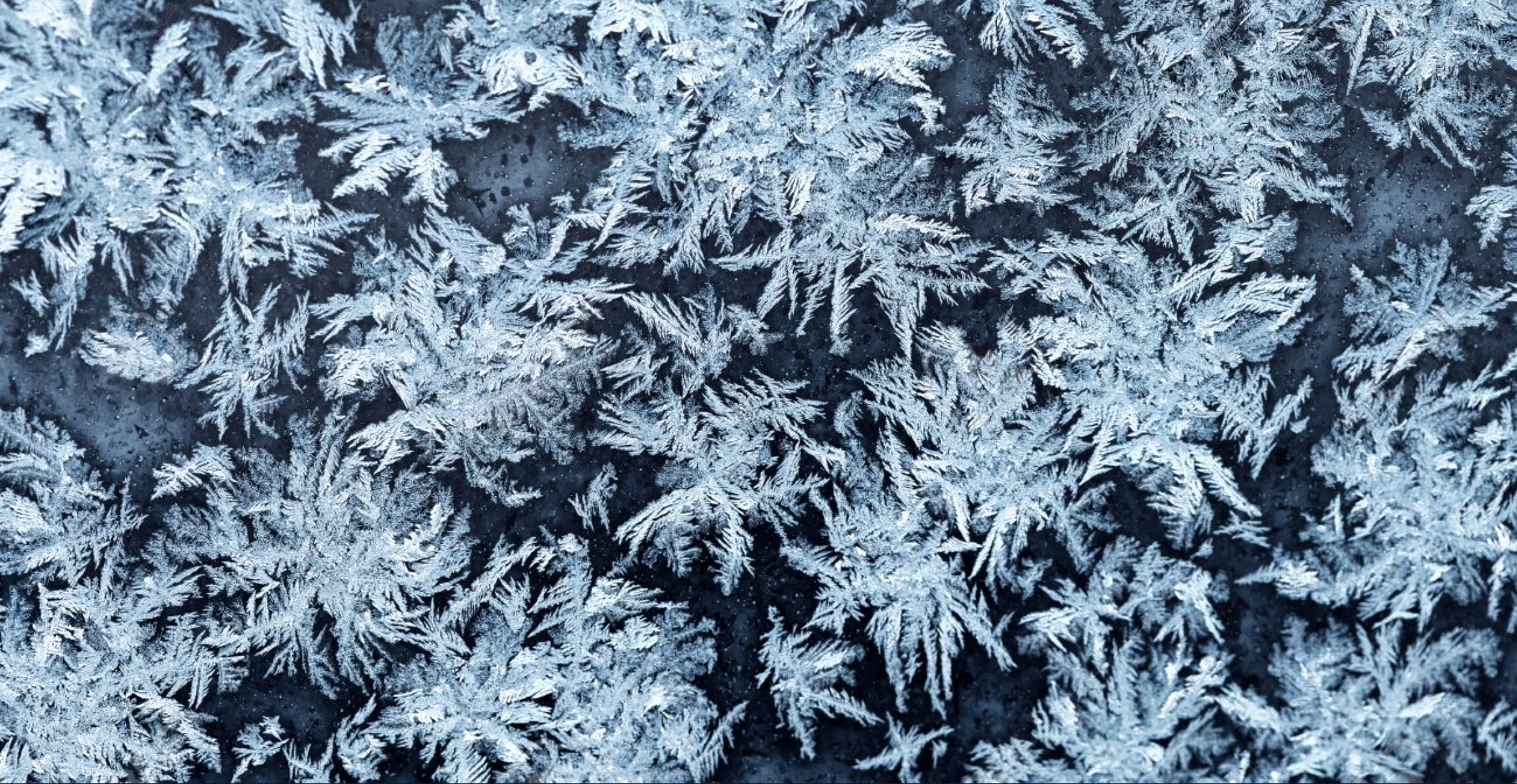
winter activities
There are a range of winter activities in the area from ice fishing on Summit Lake, to cross country skiing, snowshoeing, tubing and sledding. For snowshoe and cross country ski rentals, as well as information regarding the best places to go, visit Four Seasons Outfitters.